In Search of the Lost Civilisation
Synopsis: Atlantis Theories: Atlantis Theories explored reviewing the legend of Atlantis, Plato's account of Atlantis, the original story of Atlantis and lost civilisation theories.
Nearly all of the ‘lost civilisation’ theories have become
associated with the legend of Plato’s ‘Atlantis’, thus the concept and its study
have been largely ignored by the serious academic community.
Yet ironically it is probably the legend of Atlantis
itself, however fanciful, that has provided the foundation for the belief in the
existence in a pre-historic civilisation to account for the out-of-place
knowledge and artefacts detailed in previous chapters.
Atlantis was first mentioned by Plato in his work, the
‘Timaeus’, in which he detailed the mighty island of Atlantis and its
proud peoples who, is the course of "a single day and night" were swept by
earthquake and flood into the depths of the ocean’.
Despite his pupil
Aristotle’s belief that the story was fantasy, invented to moralise on the
nature and consequences of human ambition, Plato was adamant that the former
existence of Atlantis was a matter of historical fact. Whatever the truth, the legend certainly was considered factual
for many centuries with even mediaeval sea-charts showing unknown ‘Atlantis’
islands.
Yet if there was a ‘lost civilisation’ (regardless of its
connection with or not to the Atlantis legend) it would have had to have had a
home, and any identified location would have to provide supporting evidence that
a civilisation actually did live there, for, as Egyptologist Mark Lehner rightly
points out, without evidence of remains, it would be safer to conclude that that
there was no former civilisation, and the purported clues to its existence would
have to be explained in some other way.
Many locations for the lost civilisation have been suggested with
many of them centring on the Mediterranean area. A Dr. James Mavor set out one
theory in his 1969 book, believing that the lost peoples were a Minoan
civilisation. This followed earlier claims first set out in the 1930s by Greek
scientists Dr Angelos Galanopoulos and Professor Spyridon Marinatos (below right).
|
|

There is certainly some evidence to support Thera, an island
near Crete in the Mediterranean, being the location of an early civilisation.
Professor Marinatos, under the auspices of the Archaeological Society at Athens,
began a systematic excavation of a town on the island, Akrotiri in 1967, after
evidence of early habitation had been discovered there in the second half of the
19th century.
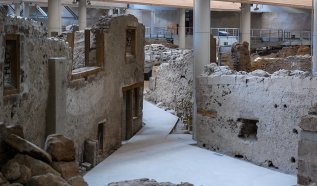
These excavations confirmed that Akrotiri had been one of the most
important prehistoric settlements of the Aegean, and the various imported items
discovered indicated a wide network of external relations. Not only as Akrotiri
in contact with nearby Crete but it also communicated with mainland Greece, the
Dodecanese, Cyprus, Syria and Egypt.
However, it appeared that the town’s life came to an abrupt end
in the last quarter of the 17th century BCE when the inhabitants were
forced to abandon their homes as a result of severe earthquakes. An eruption of
the island-volcano Thera followed, with volcanic materials covering the
entire island and the town itself, preserving the buildings (above) and their
contents forming an intriguing time capsule just like as at Pompeii.
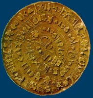
Despite evidence of early civilisation, the evidence was
not early enough, with the first signs of habitation being from the late
Neolithic times (c. 4th millennium BCE.) Attention therefore turned
to Crete itself, Thera’s much larger neighbour, and a popular choice for the
home of the ‘missing’ civilisation.
A ceramic disc (right) had been found at Phaistos on Crete
which was around 3700 years old, however made from a clay not indigenous to the
island, indicating that Crete had certainly been visited by that time. Indeed,
other evidence suggests that the island was in fact occupied at least by
6000BCE; indicating the existence of a sea faring people who had boats that
could be rowed out into open sea.
Whenever the civilisation started, history records that by
1500BCE Crete had become the centre of a seafaring empire. However, within a
very short time, this empire collapsed along with its infrastructure. In all
probability this collapse was caused by the eruption of a volcano (left) that
destroyed the nearby island of Thera and also deposited layers of ash that would
have destroyed harvests for decades. The eruption is also known to have
triggered off a substantial tidal wave.
These events appear to fit the story handed down by Plato of
the island paradise, Atlantis. Indeed the volcano at Thera erupted exactly 900
years before Solon received the original story of Atlantis from Egyptian priests
leading to some concluding that Plato might have got his figures wrong; he
should have referred to Atlantis being destroyed 900 years previously, not 9000
years. There were other indications that Crete could have been the legendary
Atlantis. Crete was well known to the Egyptians as ‘Keftui’, a land that
was "the way to other islands and the continent beyond" exactly as Plato
described Atlantis.
|
Not so, retorted Dr. Jurgen Spanuth, who was familiar with
Plato’s account of Atlantis. "Neither Thera nor Crete lies in the Atlantic …
Neither island lies at the mouth of a great river, neither was swallowed up by
the sea and vanished … in fact this great breakthrough in archaeology is a
bubble that burst long ago."
Spanuth (right) wasn’t having any nonsense about some
mythical lost continent lying somewhere in the Mediterranean. Absolutely not.
No, as far as he was concerned, Atlantis was to be found on the sunken islands
near Heligoland off the northwest German coast.
He attempted to prove his theory in his 1976 book ‘Atlantis
of the North’ but, of course, could not.
History advises us of other submerged archaeological remains in
the European area. Pliny the Elder and Strabo make reference to the Etruscan
city of Spina in the Adriatic, which was once a thriving metropolis of trade and
culture, but now completely submerged. Similarly, Dioscuria, an ancient Greek
port of considerable size is now beneath the surface of the Black Sea. (1)
Other nominations for the location of
‘Atlantis’ within the Mediterranean have included a site off the coast of
Morocco where scuba divers chasing fish discovered a well-built 9-mile long
under water wall traversing an underwater mountain.
These ruins were investigated by Dr. J
Thorne who also noted the existence of roads going still further down the
mountain into the inky depths of the sea.
However, T C Lethbridge, a Cambridge archaeologist and
psychical researcher, believed that the missing civilisation’s home could have
been located at Tartessos, which lay between two rivers in southern Spain, just
outside the straits of Gibraltar (the Pillars of Hercules.)
It is believed that
the Carthaginians conquered this rich and civilised city before being destroyed
by the 6th Century BCE, however it was reported to have written
records that went back to 6000 year before its disappearance (2).
However, despite these romantic notions, there is no real
evidence that Europe or its environs could have been the location of the missing
civilisation. Indeed Plato, who had suggested the idea of an Atlantis, had
actually stated that the alleged colony lay beyond the ‘Pillars of
Hercules’ at Gibraltar.
And there appears to be some evidence that
it may well have done.
The Azores are a group of islands lying ‘beyond Gibraltar’
that have frequently been proposed as a possible location of the lost
civilisation. The first person to make such a proposal was Ignatius Donnelly
(1831-1901). Donnelly (right) was a respected statesman, who served in the US
Congress from 1863 to 1869 and wrote several works, including a treatise on
‘Atlantis, the Antediluvian World’. In that work he stated:
|
"Deep sea soundings have been made by ships of
different nations; the United States ship Dolphin, the German frigate
Gazelle, and the British ships Hydra, Porcupine and
Challenger have mapped out the bottom of the Atlantic [Challenger map
below], and the result is the revelation of a great elevation, reaching from a
point on the coast of the British Islands southwardly to the coast of South
America, at Cape Orange, thence south-eastwardly to the coast of Africa and
thence southwardly to Tristan d’Acunha. … The submerged land … rises about 9000
feet above the great Atlantic depths around it, and in the Azores, St. Paul’s
Rocks, Ascension, and Tristan d’Acunha it reaches the surface of the ocean."
(3).
"Evidence
that this elevation was once dry land is found in the fact that the
‘inequalities, the mountains and valley’s of its surface, could never have been
produced in accordance with any laws for the deposition of sediment, nor by
submarine elevation; but, on the contrary, must have been carved by agencies
acting above the water level." (4) Donnelly concluded that the area was the
probable location of the missing Atlantis.
The then British Prime Minister, William Gladstone, was so
impressed with Donnelly’s finding’s that he sent a letter of appreciation on
publication of the book, and even went so far as to request that the British
Parliament approve the use of the Royal Navy to search the area for evidence of
the lost civilisation. Unfortunately for Donnelly, the fleet was engaged
elsewhere at the time and so the search never took place. (Unfortunately for
Shakespeare, Donnelly also became famous for discovering a cipher in the bard’s
work suggesting that he had not written all that he was credited for, and that
Francis Bacon was the true author of some of the texts.)
The Azores, themselves, are constantly subject to volcanic
activity; the picture, below, was taken by the Space Shuttle and shows volcanic
smoke over Pico Island. Altogether there are five active volcanoes situated in
the Azores area, and it may well be that such volcanic activity could account
for the disappearance of an entire civilisation just as it had in Crete.
Volcanic activity cannot just make living conditions untenable,
but is also known to have a significant impact on the land and seascape. For
example, in 1808 a volcano rose in San Jorge to a height of several thousand
feet, and in 1811 a volcanic outpouring created a large island which was called
Sambrina during its short above-water existence before it sank again beneath the
sea. The Azore islands of Corvo and Flores have also constantly changed shape
over the centuries, with large parts of Corvo presently under the sea (5).
More recently, on 14th November 1963, the skipper of
a fishing boat off the south coast of Iceland radioed his base to report a large
cloud of black smoke rising from the sea. He and his crew went on to watch as a
huge explosion sent rocks hurtling into the sky, before a black land form
emerged from the ocean depths. Within twenty-four hours the new island was
higher than a house, and within a week its peak was 200ft above sea level.
Eruptions continued and, by 1967, the new island, named
Surtsey (after the Norse god fire god Surtur), had reached a height of 500 foot
and was over a mile long. Today, colonised by birds and vascular plants, the
island stands as proof that new land can emerge from the depths as quickly as an
old one can sink into legend:- and there is evidence to suggest that some of the
land now under water around the Azores was once above sea level, lending further
support to the idea that these islands could have been the home of a lost
civilisation.
But for a civilisation, there would not only
have to be land but lost artefacts discovered on that land, and, again there is
some evidence that such artefacts have been found. One such find was made by the crew of the
SS Jesmond, a British merchant vessel of 1,495 tons that set off for New Orleans
from Messina in Sicily at the end of the nineteenth century. In March 1882 the
ship passed through the Straits of Gibraltar into the open sea. Some 200 miles
west of Madeira, and a similar distance south of the Azores, the crew observed
numerous dead fish and muddied waters. Later the same day smoke was observed,
although it was assumed to be from another vessel. The following day, there were
even thicker dead deposits of fish and the smoke was more visible, appearing to
come from a land mass where charts and maps indicated there should be open
waters.
The Captain of the Jesmond, David Robson, (Master’s Certificate
No 27911 in the Queen’s Merchant Marine), cast anchor about 12 miles from the
newly formed landmass, but far from sinking thousands of fathoms as the maps
indicated, the anchor hit the sea floor after only seven fathoms.
Robson subsequently took a landing party ashore the new island
to explore. When the ship ended its journey and docked in New Orleans and Robson
gave an account of his findings to a reporter from the Times Picayune. He
described how they had uncovered crumbling remains of massive walls and
recovered artefacts including "bronze swords, rings, mallets, carvings of heads
and figures of birds and animals, and two vases or jars with fragments of bone,
and one cranium almost entire … [and] what appeared to be a mummy enclosed in a
stone case… encrusted with volcanic deposit so as to be scarcely distinguished
from the rock itself (6).
Robson advised the reporters who examined his finds that he
intended to donate them to the British Museum, however at that point
verification of these claims becomes difficult for the log of the SS Jesmond
along with the offices of the ship’s owners, ‘Watts, Watts and Company’
was destroyed during the London blitz of September 1940. The British Museum now
has no record of any such donation from Robson (7).
Despite this lack of corroboration, there is other supporting
evidence of Robson’s discoveries. The unfortunately named Captain James Newdick
of the steam ship Westbourne was sailing from Marseilles to New York
during the same period when it reported sighting a large uncharted island in the
area where Robson had landed. Other captains also reported floating fish which
were eaten by the sailors, indicating that the fish’s demise was sudden and not
the result of some epidemic disaster (8).
|
History has also revealed that just as lands have emerged from
the depths in that area, other land now under water was once above sea-level.
One such piece of evidence was uncovered during the 1898 laying of a
transatlantic cable (below). As during earlier attempts, the cable snapped and
the workers were required to pull it to the surface for repairs. This incident
occurred some 500 miles to the north of the Azores.
Whilst searching for the cable, the sea floor in the area
was found to be composed of rough peaks, pinnacles and deep valleys, more
reminiscent of land than the expected sea bottom. Grappling irons brought up
rock specimens from a depth of 1700 fathoms. These rocks proved to be tachylyte
– vitreous basaltic lava that cools above water under atmospheric pressure
(9).
According to Pierre Termier, a French geologist who made a
study of the incident, if the lava had solidified under water it would have been
crystalline instead of vitreous (10).
Termier further surmised that the lava had been submerged under
water soon after cooling, as evidenced by the relative sharpness of the material
brought up. Although it cannot be ascertained exactly when this occurred, it was
certainly within the last 15,000 years as lava decomposes in that time. Further
evidence of more recent underwater activity comes from a discovery in 1923 when
technicians from a Western Telegraph ship searching for a lost cable in the
Atlantic detected that the rising ocean bed had thrown up the cable by 2.25
miles in only twenty-five years (11).
In 1949, Professor M Ewing of Columbia University was exploring
the mid-Atlantic ridge. At a depth of between two and three and a half miles, he
discovered pre-historic beach sand. This puzzled Ewing, as sand, being the
product of erosion should be non-existent on the seabed. The conclusion reached
was that either the land sank, or the ocean level was much lower in a past epoch
(12).
There are other interesting finds. In the course of a submarine
probe by the Geological Society of America in 1949, about a ton of limestone
discs were lifted from the bed of the Atlantic, just south of the Azores Island
chain. Their average size was about 6 inches with a thickness of 1.5 inches. The
discs had a peculiar cavity in their centre. On the outside they were relatively
smooth, but, in the cavities, they were rough. These ‘sea-biscuits’ as
they were called, did not appear to be a natural formation and could not be
identified. According to the Lamont Geological Observatory (Columbia University)
"the state of lithification of the limestone suggests that it may have been
lithified under subariel conditions and that the seamount may have been an
island within the past 12,000 years." (13).
Other claims that the Azores may have been the location of a
lost civilisation were supported by alleged sightings in the area of underwater
buildings and entire ‘cities’ made from aircraft as far back as 1942. These
sightings first started when air ferry pilots flying from Brazil to Dakar
glimpsed what appeared to be a submerged city on the western slope of mountains
in the mid-Atlantic ridge.
|
|
TAGS:
Atlantis Theories, Atlantis Theories Explored, Legend of Atlantis, Plato's Account of Atlantis, Original Story of Atlantis, Lost Civilisation Theories 
 |